
You are heresatellite
satellite
Insat-3D

INSAT or the Indian National Satellite System is a series of multipurpose Geo-stationary satellites launched by ISRO to satisfy the telecommunications, broadcasting, meteorology, and search and rescue needs of India. Commissioned in 1983, INSAT is the largest domestic communication system in the Asia Pacific Region. The satellite will be monitored and controlled by Master Control Facilities that exist in Hassan and Bhopal.
SARAL
SARAL mission results from the common interest of both CNES and ISRO in studying ocean from space using altimetry system and in promoting maximum use of the ARGOS Data Collecting System. Radar altimetry by satellite is a technique used in oceanography to measure, globally over the oceans, the sea level needed to understand ocean circulation and its variability.
Megha Tropiques
Megha-Tropiques is an Indo-French Joint Satellite Mission for studying the water cycle and energy exchanges in the tropics. The main objective of this mission is to understand the life cycle of convective systems that influence the tropical weather and climate and their role in associated energy and moisture budget of the atmosphere in tropical regions.
Oceansat
Oceansat-2 satellite mainframe systems derive their heritage from previous IRS missions. Oceansat-2 was launched by PSLV-C14 from Satish Dhawan Space Centre, Sriharikota on Sept. 23, 2009.
Satellite INSAT IMAGE-VIS INDIA SECTOR

INSAT IMAGE-VIS INDIA SECTOR
Satellite Images INDIA SECTOR IR-INSAT IMAGE

INDIA SECTOR IR-INSAT IMAGE
Frequently Asked Questions on Tropical Cyclones

Frequently Asked Questions
on
Tropical Cyclones

KALPANA
Metsat is an exclusive meteorological satellite of ISRO in geo-synchronous orbit. This satellite is developed out of a small I-1000 bus made of carbon fibre re-enforced plastic light weight structure, a uni power bus employing an 18AH Ni-Cd battery and a single GaAs/Ge solar panel generating 640 watts of power. Metsat uses a 3-axis stabilized momentum biased attitude control system with suitable linearly controlled magnetic torquers for solar radiation pressure compensation.


All India Sea State Weather Forecast Forecast

Sea State Forecast
All India Weather Forecast

All India Experimental Short Range Weather Forecast
MOSDAC- New Version

Application of Space Technology for the benefit of the comman man.
Weather forecasting, cyclone prediction & continuous weather & ocean data availability.
Satellite INSAT IMAGE (Enhanced Visible Channel)

INSAT IMAGE (Enhanced Visible Channel)
Satellite Images INSAT IMAGE (NORTH EAST SECTOR)

INSAT IMAGE (NORTH EAST SECTOR)
Bangalore University Info, Facts, Gmaps | Google Satellite Maps
Facts about Bangalore University
* Campus
* Mark Johnson Addresses the Spectators
* Images courtesy Flickr.com and its vibrant members
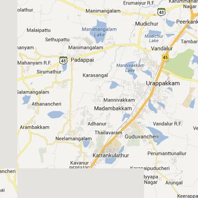
Google Satellite Maps of Madambakkam | செயற்கைக்கோள் வரைபடங்கள் Madambakkam
Google satellite maps of Madambakkam(இந்திய Google செயற்கைக்கோள் வரைபடங்கள் Madambakkam)
 .
.
Follow read more to view Madambakkam Google satellite maps.
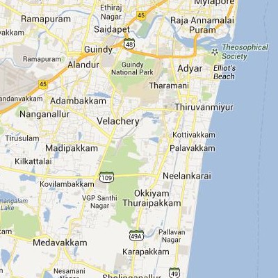
Google Satellite Maps of Perungudi | செயற்கைக்கோள் வரைபடங்கள் Perungudi
Google satellite maps of Perungudi(இந்திய Google செயற்கைக்கோள் வரைபடங்கள் Perungudi)
 .
.
Follow read more to view Perungudi Google satellite maps.
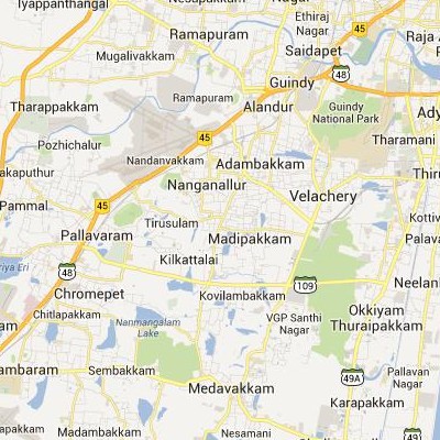
Google Satellite Maps of Madipakkam | செயற்கைக்கோள் வரைபடங்கள் Madipakkam
Google satellite maps of Madipakkam(இந்திய Google செயற்கைக்கோள் வரைபடங்கள் Madipakkam)
 .
.
Follow read more to view Madipakkam Google satellite maps.
